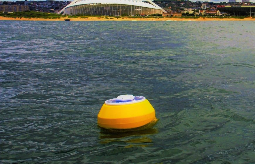
Real-time environmental observations in the water sector, such as measuring waves, water levels and water quality, have traditionally been expensive. Obscape, which recently joined the membership of the Netherlands Water Partnership (NWP), breaks with that tradition by launching a range of wireless solar powered solutions that are reliable, easy-to-use and cost-effective. Obscape’s Director Max Radermacher talks about Obscape’s ambitions for growth, especially in complete monitoring networks, and how it can do this with NWP and its members.
Max Radermacher, Director of Obscape, started the company with his partner Zane Thackeray 10 years ago. "I met Zane when he was surveying the coast and inland waters in and around Durban, South Africa, for the municipality. At the time, this was still done using conventional measuring equipment which is not always user-friendly as maintenance is challenging and the equipment expensive and susceptible to theft. An industry standard wave buoy easily costs EUR 50,000 while the sensors only cost a few euros. We thought it could be done better and more cheaply by using wireless, solar powered mobile networks and satellites. And we came up with a solution that is a dozen times cheaper. This is our wave buoy today. It is rugged, lightweight, reliable and affordable. It uses a combination of motion sensors and an electronic compass to accurately measure a range of bulk wave parameters such as significant wave height, wave period and wave direction.”
Broadening the portfolio
In the meantime, Obscape has worked hard to widen its portfolio while sticking to the principle of easy-to-use and reliable real-time equipment. The expanded product range now includes weather, rain, and camera devices. The solar panels and the mobile modem have been fitted as inconspicuously as possible, making the products less susceptible to theft. Radermacher continues, "We also developed a system to monitor the water level using a downward-pointing radar which could be placed under a bridge, for example. The radar continuously measures the distance to the water surface. This can be combined with time-lapse camera images as we know that many customers also like to monitor visually as well. In Durban, we set up a monitoring network with 150 sensors, all of which supply real-time data. It can be used to monitor various things such as the rivers that flow into the Indian Ocean there. This is a very dynamic river system with a lot of sediment transport which can accumulate and cause the beach to close off the river mouth at a certain point. The water level in the river then rises until it breaks through again. Our water level gauges, cameras and rain gauges are a useful combination of tools to observe that process.”
Digital water collaboration
Obscape clearly sees a future in collaboration with organisations in the field of computer modelling, hydraulic engineering and water management. Models and measurement data go hand in hand and reinforce each other. They can be used to validate models and determine the extent to which predictions come true. Radermacher explains. “Take dredgers, for example. They cannot work if the waves are too high, so if high waves are forecast, they stay ashore. Keeping dredgers berthed is expensive and dredging companies can take out insurance for this. But to claim that insurance money, it is essential to prove that the waves really were too high.”
Platform hosts sensors’ data
Much of Obscape's portfolio is based on its Power and Telemetry Module (PTM), developed in-house, which serves as a basic solar powered and wireless mounting platform to which various things can be added. The PTM can host a range of sensors, including those of third party manufacturers, to communicate in real time with satellite or GSM connections through the Obscape data portal. According to Radermacher, "by consolidating various measurements into a single portal, a large network of devices can easily be monitored and maintained. Graphics, charts, and setting thresholds and alerts are some of the features available. We provide the data portal for free, customers do not pay for a subscription or a license. We don't want to make the customer pay to view their own data."
More R&D through growth
“In five years' time, we will have grown considerably and will also have developed new products. For example, we are currently designing a buoy to measure water quality and I foresee a strong development in the field of cameras,” says Radermacher. “We hope to take our R&D to a higher level. So far, we have managed to fund our company entirely from our revenue. We expect that this strategy will still give us enough space to grow.”
Matchmaking and building consortia
Selling individual products is going well for Obscape, but as Radermacher says, “we are still young and building our brand awareness and reputation. It is not easy for us to identify key players in international markets, especially public organisations. So the matchmaking role of NWP can be very valuable to us. We see many opportunities in NWP to set up complete monitoring networks as a part of integrated solutions. We look forward to working with other NWP members and networks abroad, especially for governments. There is a glaring lack of public private cooperation in many places in the world. It is key to make integrated solutions with several parties available and to involve local partners who contribute local know-how. Take Southeast Asia for example, and the recent floods that hit Jakarta again. I am sure that building consortia will generate excellent opportunities to put a convincing and comprehensive joint tender on the table."
Featured NWP members: Obscape
