Blog
8 July 2021First steps towards a resilient Senegal River Delta
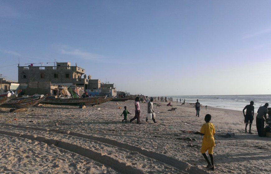
The city of Saint-Louis in northern Senegal, where the Atlantic Ocean and the Senegal River meet, is a city under stress. Coastal erosion is causing part of the city to disappear into the sea. Periodic flooding combined with heavy rains lead to inundations of the city. The natural balance of the wider delta of the Senegal River is very delicate. The whole region is vulnerable to manmade interventions and climate change.
The Senegalese Government is prioritising a resilient Senegal River delta. At the moment, the Government is focusing on the lower delta and the protection of the city of Saint-Louis. Two studies exploring solutions for these areas are being conducted. Thereafter, the Dutch water sector can make an important contribution to addressing the challenges in the delta.
The city of Saint-Louis, a UNESCO World Heritage Site in northern Senegal, has been battling coastal erosion and the periodic flooding of the Senegal River for decades. Multiple challenges come together in the Senegal River delta, a UNESCO Transboundary Biosphere Reserve. The effects of climate change are making the coastal zone around Saint-Louis even more vulnerable. In tackling these problems, the Government of Senegal is having two preparatory studies map the situation and explore options to address Saint-Louis' challenges. The follow-up is likely to provide ample opportunities for the Dutch water sector to engage.
Deltares, the Dutch research institute, and the French engineering firm Egis, are conducting the studies. The first study focuses on the lower delta of the Senegal River. The second study touches on the city of Saint-Louis itself, paying special attention to the neighbourhoods located on the Langue de Barbarie sandspit. Both studies are developing different scenarios targeting the protection and reinforcement of the entire coastal zone.
Saint-Louis as a national concern
The problems around the mouth of the Senegal River, which flows into the sea at Saint-Louis, are wide-ranging and complex. The sandy peninsula in front of the old centre that protects the city from the sea is slowly crumbling into the Atlantic Ocean. The old fisherman’s districts on the Langue de Barbarie sandspit, with its 62,000 inhabitants, are in danger of disappearing. Apart from coastal erosion, regular river floods pose major challenges for the city. These problems are compounded by rising sea levels and heavier rainfall.
The artificial breach in the peninsula, made in 2003 because of the danger of flooding, covered only a couple of metres, but currently measures about six kilometres. This breach leaves the hinterland without protection and has led to coastal erosion and salinisation of the soil to the south of Saint-Louis. In addition, local fishermen use the dangerous mouth to reach the sea, resulting in deaths.
Senegal has been keen to make Saint-Louis and the delta more resistant to water. In addition to the protected natural areas and the approximately 400,000 people who live in and around Saint-Louis, the city has great symbolic value as the historic town centre is a UNESCO World Heritage Site.
Protecting Saint-Louis also fits in with the broader national policy on climate adaptation. Senegal is a low-lying country with a long coastline, coastal urban development, and multiple delta areas. The country's economic activity is concentrated on the coast. Rising sea levels, heavy rains and extreme weather hit Senegal hard, so adaptation is vital. That is the reason that Senegal is one of the convening countries of the Global Commission on Adaptation.
Vulnerable Senegal River Delta
The Senegal River flows into the Atlantic Ocean at Saint-Louis after a journey of about 1,600 kilometres. The Senegal River flows through Guinea, Mali, Mauritania and Senegal and is the second longest river in West Africa after the Niger.
Fresh and salt water meet in the delta. The building of the Diama and Manantali dams upstream allow the abundant rainwater to be used for irrigation. Since their building, irrigated agriculture, especially rice farming, has taken off in north Senegal. The river delta has become one of the largest irrigated agricultural areas in West Africa. However, irrigation is also causing salinisation and soil degradation, thus threatening agriculture at the same time.
The river delta consists of several basins and floodplains fed by high water, lakes and the sea. There are several protected natural reserves, both in Senegal and Mauritania. The Oiseaux du Djoudj National Park in Senegal is a Ramsar Wetland site and houses more than 350 different species. The delicate balance in the protected areas is vulnerable to changes in the water balance, and invasive plants proliferated after the construction of the Diama dam.
Dutch involvement
The Dutch water sector has been involved in the Saint-Louis area in the past. The Dutch Risk Reduction (DRR) Team, initiated by the Dutch Government, organised two missions to Saint-Louis in November 2014 and February 2015. The DRR Team made recommendations for follow-up studies to the Senegalese Government. The Rivierenland Water Board also works closely with the Organization Pour la Mise en Valeur du Fleuve Sénégal (OMVS), the regional organisation for the Senegal River basin in which Senegal, Mauritania, Mali and Guinea are partners.
Dutch involvement is ongoing with Deltares conducting the above-mentioned studies. The first one is part of the Storm Water Management and Climate Change Adaptation Project (PROGEP) and covers the challenges in the estuary of the Senegal River. It is a follow-up of the DRR mission. The second study, jointly conducted with Egis, is framed under the Saint-Louis Emergency Recovery and Resilience Project (SERRP) to propose a long-term solution for the erosion of part of the sandy peninsula in front of the city and the recurrent stagnation of pluvial and river water in low-lying parts of the city.
Tackle the challenges
The PROGEP and the SERRP studies provide a framework to address the challenges in the coastal zone. The PROGEP study explores options that include the application of nature-based solutions where the mouth of the river naturally moves southward by creating artificial breaches in the Langue de Barbarie.
The PROGEP study also proposes no regret measures that must be applied regardless of the option chosen. The measures include: strengthening dikes and quays in the city; sand nourishment and dredging at various spots; placing buoys to mark a navigation channel in the mouth of the river; and, upgrading of flood protection works in the city.
The SERRP study explores options to counter the erosion of the Langue de Barbarie. An emergency dike is currently being constructed on the peninsula, but this is a temporary solution. The options being investigated are: widening the beach; placing groynes with beach nourishment between them; limited beach nourishment combined with resettling the residents; constructing breakwaters; and sand nourishment.
Looking ahead
The PROGEP and SERRP studies will be completed at the end of the summer and at the beginning of next year respectively. The Senegalese Government will choose one of the PROGEP options and one of the SERRP options. Thereafter, the Government will begin a preparatory project and will further explore the selected options. The no regret measures will also be subject to follow-up studies. These are expected to lead to infrastructural works.
The financing of the follow-up studies has not yet been finalised, but the World Bank is closely involved in the follow-up and several donors are interested in funding follow-up projects.
The Dutch water sector has always shown great interest in the challenges of Saint-Louis and the wider delta region. The results of the PROGEP and SERRP studies, and the choices that Senegal will make, form the framework for further engagement. There seems to be ample opportunities, and the challenges fit well with what the Dutch water sector has to offer. For further information on the studies, contact Pyke Polderman, Second Secretary at the Dutch Embassy in Dakar, at pyke.polderman@minbuza.nl or visit https://www.deltares.nl/nl/projecten/saint-louis-gevangen-tussen-twee-bedreigingen/.
________________
Pyke Polderman is Second Secretary at the Dutch Embassy in Dakar. Polderman works in the economic section of the Embassy and his remit includes coastal protection. The Dutch Embassy in Dakar cooperates with the Senegalese Government to tackle coastal erosion and address the challenges in Senegal’s deltas. In doing so, it draws on the knowledge and expertise of the Dutch water sector.
